The Royal Victoria Marathon - Event Details and Traffic Advisories
FOR IMMEDIATE RELEASE
October 9, 2026
Victoria, B.C. – Traffic disruptions, temporary CCTV cameras, and a Remotely Piloted Aircraft System (RPAS) will be deployed to support public safety and maintain traffic flow during the Royal Victoria Marathon on Sunday, October 11.
The Royal Victoria Marathon will cause temporary traffic disruptions along the event route throughout Greater Victoria, including downtown Victoria, the Inner Harbour, James Bay, Beacon Hill Park, Fairfield, Oak Bay, the Uplands, and Dallas Road.
Motorists, cyclists, and pedestrians will not be able to cross the downtown race route between approximately 7:55 a.m. and 9:30 a.m. on Sunday, October 11. Expect runners and walkers along the race route from approximately 7:00 a.m. to 3:30 p.m. on Sunday.
A map of the marathon race route is below.
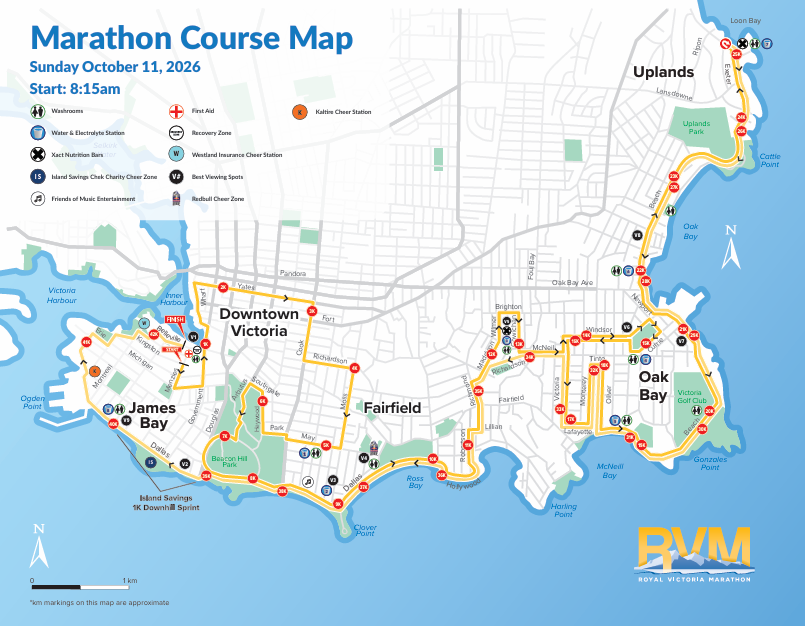
In addition to the Royal Victoria Marathon, a half marathon and 8-kilometer race will also take place, attracting more than 15,000 participants and 5,000 spectators. Further information about all the Royal Victoria Marathon events can be found here.
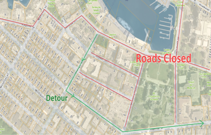
Please familiarize yourself with the race route and expect to encounter road closures if entering or leaving the downtown area on Sunday. Allow yourself extra time to reach your destination, especially if you are travelling to the airport, BC Ferries, or the Black Ball Ferry Line’s M.V. Coho or FRS Clipper.
Due to heavy traffic in the area, please note the Black Ball Ferry Line’s M.V. Coho detour outlined on the map below. Please review the available traffic route and allow extra time for travel. Thank you for your patience and cooperation.
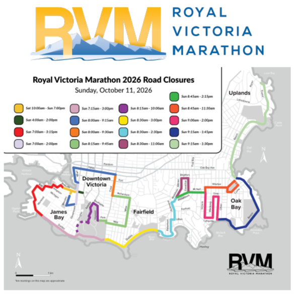
All other roads identified on the previous map, including those in James Bay and along Dallas Road and Fairfield Road, will remain closed to all traffic until the last runner has passed.
Temporary CCTV Cameras and RPAS Deployment
The deployment of CCTV cameras and the RPAS is an integral part of VicPD’s efforts to support community safety and is in accordance with B.C. and national privacy legislation. Temporary signs indicating CCTV camera presence will be displayed in event areas to inform the community, and the cameras will be removed once the events have concluded. The RPAS camera has live stream capability and will not be recording by default.
Residents in downtown Victoria, the Inner Harbour, James Bay, Fairfield, Oak Bay, and the Uplands, as well as visitors to Beacon Hill Park, should expect delays entering and leaving the area during the event on Sunday. Motorists are encouraged to arrive early, allow extra travel time, and consider walking, cycling, or taking BC Transit where possible.
VicPD and partner agencies Special Duty members will be on site throughout the event to help manage traffic, support participant safety, maintain public safety, and ensure access to emergency vehicles.
If you see suspicious activity, an unattended item, or anything that concerns you, notify a VicPD officer or event staff. You can also call the E-Comm non-emergency line at 250-995-7654, ext. 1, or call 9-1-1 in an emergency.